Apartments in Boston's West End: What Renters Should Know
Boston's West End is small, extremely well connected and almost entirely rebuilt. This is what it is actually like to live there: door-to-door walk times re-verified in October 2026, the 1958 demolition that shaped it, and the honest cost of living two blocks from TD Garden.
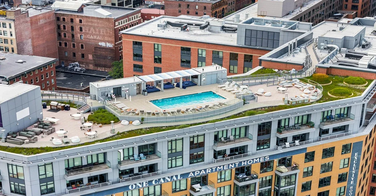
Where the West End actually sits
Boston's West End is the wedge of ground between the Charles River, Beacon Hill and the North End, with North Station and TD Garden at its northern edge and Massachusetts General Hospital at its western one. It is small. You can cross it on foot in about fifteen minutes without hurrying, and most renters who move here end up doing exactly that several times a day.
The address this article is written from is 1 Canal Street, at the eastern corner of the neighbourhood in the pocket the real-estate trade calls the Bulfinch Triangle. Renters almost never use that phrase, so it is worth translating: it is the triangle of nineteenth-century brick warehouse streets between Causeway Street and Haymarket that survived when the rest of the neighbourhood did not. Everything measured below was routed door to door from that point on 5 October 2026, using the OpenStreetMap foot-routing engine, against the coordinates One Canal publishes in its own property data.
The neighbourhood was demolished, and that explains how it looks
The West End does not look like Beacon Hill, which begins two streets away, and the reason is not taste. In the late 1950s the city declared the neighbourhood a slum and levelled it. Demolition began in 1958 across a site of roughly forty-eight acres, and around twelve thousand people — a dense, largely Italian and Jewish immigrant population — were evicted and dispersed. The housing that replaced them was built for a wealthier tenant. The City of Boston's own neighbourhood record for the West End is the place to start if you want the municipal account, and the Boston Redevelopment Authority has since acknowledged the clearance as a mistake.
This matters to a renter for a practical reason, not only a moral one. When you walk the West End you are walking a mid-century plan: wide roads, long blocks, towers set back behind plazas, and very few of the small continuous shopfronts that make the North End or Beacon Hill feel enclosed. If you are moving here expecting cobblestones and a corner bakery on your own street, you will be disappointed. The old street fabric is genuinely gone. What is left of it sits in the Bulfinch Triangle, where the brick warehouses still carry painted ghost signs, and in the North End a few minutes east.
What stands there now
Today the neighbourhood is defined by three institutions rather than by its streets: the hospital, the arena and the transit hub. Mass General anchors the west, TD Garden and North Station anchor the north, and the residential buildings fill in between them. That gives the West End an unusual rhythm. It is busy at shift-change hours and on event nights, and noticeably quiet on a Sunday morning when neither the hospital nor the Garden is turning over.
It also means your neighbours are not a single type. Medical staff, students, commuters who want a train they can walk to, and people who moved for the hospital and stayed are all here in numbers. The building this is written from reflects that mix fairly directly, and if you want the full picture of what living in it involves, the One Canal renter's guide covers the building itself rather than the neighbourhood around it.
A further consequence of the mid-century plan is that the West End has very little of the small-retail layer other Boston neighbourhoods run on. There is no dense row of independent shops inside the neighbourhood itself, and the places renters end up using most — the markets, the restaurants, the bars — are mostly just outside it, in the North End or around Faneuil Hall. That is workable precisely because those edges are five to ten minutes away, but it does mean the West End functions as a well-connected base rather than as a self-contained village, and renters who want the second thing should look elsewhere.
Getting around without a car
This is the strongest argument for the West End and it holds up to measurement. Haymarket station is 0.16 miles away, a three-and-a-half-minute walk, which puts the Orange and Green lines closer than most people's parking space. North Station is 0.26 miles, about five and a half minutes, and that is commuter rail to the north shore and Lowell as well as more Orange and Green line service. Both figures were routed on 5 October 2026 and both match what the community has previously published.
The practical effect is that a car becomes optional rather than necessary, which in a city where a deeded parking space is its own line item is a real saving. It also means the airport is reachable without driving, and that the inbound commuter rail platform is close enough that you can leave the flat when the train is eight minutes out rather than twenty.
The hospital and campus walk
Massachusetts General Hospital is the walk most people searching this neighbourhood actually care about. The distance is approximately seven-tenths of a mile: 0.69 miles by OpenStreetMap foot routing on 5 October 2026, against 0.66 miles in the community's own location guide. Those two independent sources agree closely on distance.
They disagree slightly on time, and it is worth being straight about why. The location guide puts it at 12.8 minutes; the routing engine returns 14.9 minutes, because the two assume different walking speeds. The honest answer is that it is a seven-tenths-of-a-mile walk that takes most people somewhere between thirteen and fifteen minutes, and that it is flat the whole way. Anyone who wants that commute examined properly — including what it means on a call schedule — will find it in the guide for students and medical residents.
Suffolk University's Tremont Street campus is closer than most people assume at 0.61 miles, about thirteen minutes on foot, routed the same day.
Where you actually buy food
Here the neighbourhood's marketing and the map part company, and the map wins.
Whole Foods is often described as being three minutes from this corner of the West End. It is not. The nearest Whole Foods is at 181 Cambridge Street and it routes at 0.45 miles, roughly a ten-minute walk, verified 5 October 2026. It is a perfectly reasonable walk. It is not a three-minute one, and a renter who signs expecting otherwise will notice in week one.
What genuinely is on the corner is Haymarket, the open-air produce market whose stalls run on Fridays and Saturdays, three and a half minutes away. Boston Public Market, the year-round indoor market hall, is 0.19 miles — about four minutes, which is the "two blocks" the listings describe and in this case the listings are right. Between the two, the everyday food situation is better than the supermarket distance alone suggests.
Event nights are the real trade-off
TD Garden is 0.26 miles from this address, about five and a half minutes on foot and genuinely two blocks. On most days that is an amenity. On event nights it is the single biggest drawback of living here, and anyone who tells you otherwise is selling something.
The arena seats well over seventeen thousand people, and when it empties, those people leave through the same streets and the same two stations you use. The sidewalks surge, Causeway Street gets loud, the bars fill, and getting a rideshare anywhere near the block becomes an exercise in walking two streets away first. This happens on Bruins nights, Celtics nights and concert nights, which in winter can mean several times a week.
It is survivable and most residents stop noticing it, but it should be a deliberate choice rather than a surprise. Higher floors and units facing away from Causeway Street make a material difference. The full version of this trade-off, including which parts of the week are worst, is set out in the guide to living near TD Garden.
Green space, the water and the edges
The West End is not a green neighbourhood, but it is bordered by better ones. The nearest edge of the Rose Kennedy Greenway — the North End Parks, at Cross Street — is 0.26 miles, about five and a half minutes, and from there the park runs continuously south through the downtown. The Charles River Esplanade sits on the other side of the neighbourhood past the hospital.
The North End begins about five minutes away on foot, at the Hanover Street entrance by Cross Street. This is another number worth correcting: it is commonly given as three minutes, and the routed figure on 5 October 2026 was 0.24 miles and 5.1 minutes. Five minutes to the North End is still an excellent thing to be able to say. Faneuil Hall Marketplace is 0.45 miles, routed at 9.7 minutes, which does hold up the usual "under ten minutes" claim.
What it costs to rent here
West End rents are Boston rents, which is to say high, and they move. AIR's pricing updates daily, so this article gives bands rather than figures, and even the bands carry a date.
As of 5 October 2026, across the seventeen plans One Canal had published, the single available studio sat in the low-$3,400s for 411 square feet. One-bedrooms ranged from the low-$4,200s at 649 square feet up into the mid-$5,100s, with a penthouse one-bedroom well above that. Two-bedrooms started in the mid-$5,200s at 976 square feet and ran to the low-$6,200s before the penthouse plans, and the single three-bedroom at 1,308 square feet sat in the low-$7,300s. The step from a one-bedroom to a two-bedroom is roughly a thousand dollars, which is why sharing a two-bedroom works out cheaper per person than taking the studio.
One charge is fixed rather than market-priced and can be stated exactly: package locker service is $75 per year, billed separately from rent, checked 10 September 2026. Utilities are billed by usage rather than bundled.
A detail that says something about the neighbourhood: the floor plans are named Haymarket, Medford, Lancaster, Portland, Haverhill, Merrimac, New Chardon, Sudbury, North Washington and Hanover. They are West End and Boston street names, several of them streets that the 1958 clearance removed.
Walk distances and times in this article were routed door to door from One Canal's published coordinates at 1 Canal Street using the OpenStreetMap foot routing engine on 5 October 2026, and cross-checked against the community's own location guide where one exists. Floor-plan counts, square footage and amenities were verified against One Canal's published property feed on 5 October 2026. The package locker charge was checked on 10 September 2026. Rents are repriced daily and are given as bands only; confirm current pricing and availability with the leasing office before relying on it.
Frequently asked questions
Is Boston's West End a good place to live?
It suits renters who want to walk to work and to transit, and who will trade neighbourhood charm for that. Haymarket is three and a half minutes away, North Station five and a half, and Mass General about seven-tenths of a mile. It suits people seeking a historic, small-scale streetscape far less, because that was demolished in 1958.
Why does the West End look so different from the rest of old Boston?
Because almost all of it was knocked down. Clearance began in 1958 across roughly forty-eight acres and displaced around twelve thousand residents, and the mid-century buildings that replaced them are what you see today. The Bulfinch Triangle, a pocket of nineteenth-century brick warehouse streets, was spared.
How far is Massachusetts General Hospital from the West End?
From 1 Canal Street it is approximately seven-tenths of a mile — 0.69 miles by OpenStreetMap foot routing and 0.66 miles per the community's location guide, both checked against each other. Expect thirteen to fifteen minutes on foot, on flat ground.
Which T lines serve the West End?
The Orange and Green lines, via Haymarket and North Station. North Station also carries commuter rail to the north of the state. Haymarket routes at 0.16 miles and North Station at 0.26 miles from 1 Canal Street, verified 5 October 2026.
Is the noise from TD Garden a problem for residents?
On event nights, yes, and it should be planned for. The arena seats more than seventeen thousand, and crowds leave through the same streets and stations residents use, so sidewalks surge and Causeway Street gets loud. Higher floors and units facing away from Causeway Street reduce it noticeably.
Can you live in the West End without a car?
Comfortably. Two stations are within six minutes on foot, groceries and two markets are walkable, and the hospital and Suffolk University are both reachable on foot in about a quarter of an hour. Most of what a car would be for is already within walking distance.
How close is the nearest supermarket?
The nearest Whole Foods is at 181 Cambridge Street, 0.45 miles and about a ten-minute walk, verified 5 October 2026 — not the three minutes sometimes quoted. Boston Public Market is about four minutes and the Haymarket stalls about three and a half.
How long does it take to walk to the North End?
About five minutes to the Hanover Street entrance at Cross Street, routed at 0.24 miles and 5.1 minutes on 5 October 2026. Some listings say three minutes; that does not hold up to routing.
What do apartments in the West End rent for?
As of 5 October 2026 at One Canal, the studio sat in the low-$3,400s, one-bedrooms from the low-$4,200s, two-bedrooms from the mid-$5,200s and the three-bedroom in the low-$7,300s. Rents are repriced daily, so treat these as bands and confirm current pricing with the leasing office.
Are there fees beyond rent?
Package locker service is $75 per year, billed separately, checked 10 September 2026. Utilities are billed by usage rather than included in rent.